Peter Meadows
Chelmsford, Essex, UK
Measuring the area of sunspot groups provides a direct and quantitative means of studying long-term solar activity, as well as the development and decay of individual sunspot groups. In the recent paper “SOHO/MDI and SDO/HMI Sunspot Area Measurement and Analysis” (Ref. [1]), a robust methodology was established for accurately measuring and comparing sunspot areas derived from the SOHO Michelson Doppler Imager (MDI) and the SDO Helioseismic and Magnetic Imager (HMI) full-disk images.
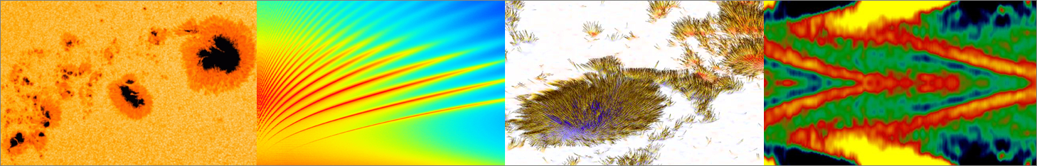
The approach used to derive full-disk and sunspot group areas employs a multistep threshold method to accurately generate sunspot penumbra and umbra masks. This method is straightforward to implement, requires no prior knowledge of sunspot locations, performs normalization to correct for image-to-image intensity variations, and removes spurious small sunspots caused by fluctuations in the intensity of the photosphere. The method has been calibrated against the Debrecen Photoheliographic Data (DPD)[2] to ensure consistency with previous sunspot area catalogues. This has been supported by visual confirmation of the successfully derived sunspot masks. Figure 1 shows example masks for the largest sunspot groups from Cycles 23, 24, and, to date, from Cycle 25.
Figure 1. Large sunspot groups showing the original SOHO/MDI and SDO/HMI images and the derived sunspot masks: AR 9393 (2001 March 29), AR 10486 (2003 November 01), AR 12192 (2014 October 24), and AR 13664 (2024 May 10).
Using SOHO/MDI and SDO/HMI images from 1996 to the present has enabled the creation of a daily full-disk sunspot area catalogue that provides the projected and corrected areas. Note that unlike the other long-term measured of solar activity, the Sunspot Number, sunspot areas are not subject to observer judgement when counting of the number of groups and sunspots. The use of satellite-based solar imagery also removes any variability caused by seeing conditions present in ground-based observations. This catalogue is available online[3].
A key result of this work is the investigation of how sunspot group areas evolve over time as the groups traverse the visible solar disk. The grouping of sunspots involves calculating the difference in longitude and latitude between each pair of sunspots. If the separation falls within an ellipse measuring 10° in longitude and 3° in latitude, the sunspots are assigned to the same group. This procedure is repeated for all sunspot pairs until every sunspot is allocated to a group. Occasionally, the automatic procedure incorrectly assigns sunspots to a single group when they would normally be split into two nearby groups. In such cases, manual intervention is required by placing a latitude/longitude boundary between the two sets of sunspots. This temporal behaviour, illustrated in Figure 2, reveals characteristic growth and decay patterns that provide insight into the life cycles of largest groups from the last three solar cycles (for SDO, images acquired every 15 minutes have been used). The latest sunspot groups, superimposed on SDO/HMI full-disk images, are also available online[4].
Figure 2. Evolution of corrected sunspot group area for the groups shown in Figure 1 as they transited the solar disk. Data derived from SOHO/MDI (AR 9393, AR 10486) and SDO/HMI (AR 12192, AR 13664).
It is suggested that the same mask-based approach can be applied to derive sunspot areas from white-light images obtained by other current and future solar satellites.
References
[1] Meadows,P.J., 2025, RAS Techniques and Instruments, 4, rzaf024, https://doi.org/10.1093/rasti/rzaf024.
[2] Gyori, L., Ludmány, A., Baranyi, T., 2017, MNRAS, 465, 1259, https://doi.org/10.1093/mnras/stw2667.
[3] Meadows,P.J., SDO/HMI Total Sunspot Area, https://petermeadows.com/SDOSunspotArea/.
[4] Meadows,P.J., SDO/HMI Sunspot Group Areas, https://petermeadows.com/SDOSunspotGroups/.